Google Maps and Earth updated with more clear and detailed satellite images
Google announced a major revamp of the cartography of Google Maps and Google Earth: New images taken by NASA’s satellite Landsat 8 will be sharper thanks to a new processing technique.
Satellite images of Google Maps and Google Earth will be ” sharper than ever, ” declares the home of Mountain View in a recent announcement. The High-resolution satellite images are now the ones captured by the NASA satellite Landsat 8 and processed using a new technique that improves the sharpness and level of detail. In explaining the new methodology, Google highlights the precautions followed to provide clear images of the Earth and not hampered by clouds.
Satellite images are often cloudy, but not always in the same place, then we have observed millions of images and used the cleanest pixels to join together these images without clouds and seamlessly.
The last update of the satellite images of Google dates back to 2013, at the time the images were provided by the satellite Landsat 7 which, due to an error that has occurred in the same year, did not allow, among other things, to make a correct mapping of some areas.
Landsat 8 was launched into orbit in 2013 and offers higher performance than the previous model in many respects: the images are captured with a greater level of detail, more natural colors and at a higher frequency.
Every day, Landsat 8 records twice as many images than those acquired by Landsat 7 in the same time interval, and the new resources have already been used by Google to provide more detailed images through its mapping app.
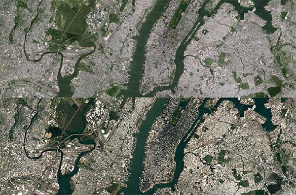
By way of example, the following table shows the New York area as represented by the images of the satellite Landsat 7 and Landsat 8: New images show more clearly the details of the skyscrapers, the baseball shadows of the buildings and fields of Central Park.
The processing technique of the new images has provided the use of the Earth Engine API, already used in other important research projects. The new Planet of the mosaic was produced using about a petabyte of data, containing more than 700 trillion pixels, among which Google has selected the most clear and cloudless, as said earlier.
A result that would not have been possible without the Landsat program, conducted by NASA and the USGS, committed since 1972 to monitor the surface of the planet. The two US government agencies gives you free access to the data collected that Google can process through the Earth Engine platform.
New satellite images are now being distributed and will be accessible through all apps Google mapping or in Google Earth and Google Maps, enabling the satellite display.