Google Maps, the new 3D toggle arrives: Here’s how it works and where to find it
The new 3D toggle allows you to enable or disable the reproduction of buildings within the Google cartography. A useful feature for devices with less computational power.

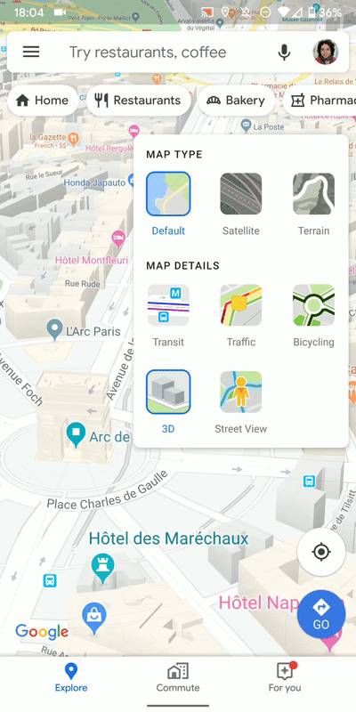
Google has introduced a small novelty on Google Maps, which could have a positive impact both in terms of performance and in terms of clarity. We are talking about the ” 3D ” toggle that appeared within the ” Map Details ” options, which allows you to clean up the cartography of the operating system by eliminating the three-dimensional shapes of the buildings. The user now has the choice to do without it through a convenient button.
Basically, Google Maps shows the polygonal details of the buildings on the screen, when available, with the aim of allowing the user to better orient himself by comparing the app data with the surrounding reality.
At the same time, it is a feature that weighs enough both in terms of graphics processing (especially on less powerful devices), and visually, and could hide details on the streets that are around the building.
Starting from version 10.28 of Google Maps for Android, it is possible to decide whether to show the three-dimensional details of the road or whether to hide them. The animation published by Android Police makes clear the differences, in which it shows the differences between the ” 3D layer ” enabled and disabled. The source shows the result with Paris, which is particularly dense in terms of buildings and details on Google Maps.
Gooogle Maps, how to disable 3D reproduction of buildings
The three-dimensional data on Google Maps is more accurate in large cities, but there are silhouettes of buildings even in smaller towns. Deactivating the function could be useful in any case on devices with less powerful hardware, relieving GPU and CPU from an additional load compared to the presentation of the cartography and navigation routines. Through the same screen, the user can also activate or deactivate other functions, such as traffic information, means of transport, bicycle routes.
The screen can be reached quickly through the icon that allows you to change the type of map, at the top right, depicted with two squares with an isometric view, one above the other. From there, simply press the 3D button to activate or deactivate the function.
Note that three-dimensional reproduction of buildings is possible only and exclusively with the ” Default ” map type, while if you are in Satellite or Relief, the Default mode will be restored for show polygonal details of buildings. The function should also arrive on iOS clients, but for the moment, it has only appeared on Android.